Log in
All resources
Create a design
494 Free Artworks of Old Maps Of London
bibliothèque nationale de france
chorographia britanniae (1741-1742)
maps from the earth and its inhabitants, vol. iv
old maps of asia
propaganda map
old maps of viceroyalty of the caucasus
voyage dans la russie méridionale et la crimée (1840-1842) par anatolii nikolaevich demidov
archibald fullarton
1529 maps
1520s maps of the caucasus
19th-century maps of the black sea
g. h. swanston
john rocque's 1746 map of london
old and new london (book)
maps from the earth and its inhabitants, vol. viii
maps of turkestan
maps from the earth and its inhabitants, vol. viii
maps of turkestan
19th-century maps of the black sea
1870s maps of the caucasus
19th-century maps of the black sea
1870s maps of the caucasus
maps of the history of morocco
empire of morocco
john rocque's 1746 map of london
details of old maps of london
the history and antiquities of london, westminster, southwark and parts adjacent
old maps of the london borough of southwark
maps from the earth and its inhabitants, vol. vi
old maps of kyrgyzstan
maps from the earth and its inhabitants, vol. vi
old maps of kyrgyzstan
the history and antiquities of the parish of lambeth, and the archiepiscopal palace (1827)
1820s maps of london
maps from the earth and its inhabitants, vol. vii
old maps of jiangsu
maps of barbary coast
old maps of tartary
maps from the earth and its inhabitants, vol. vii
floods in china
maps from the earth and its inhabitants, vol. xi
old maps of the sahara
untrodden peaks and unfrequented valleys (1873)
old maps of the alps
maps from the earth and its inhabitants, vol. xvi
1870s maps of mexico
english-language books about london
old maps of the city of london
1849 maps of north america
old maps of canada
19th-century maps of crimea
g. h. swanston
1770s maps of alaska
robert de vaugondy
old maps of the bering sea
old maps of kamchatka
19th-century maps of the black sea
1870s maps of the caucasus
18th-century maps of the indian ocean
bodleian maps collection
old maps of the london underground
maps by macdonald gill
the new forest, its history and its scenery
symbolism
maps of the cape of good hope
old maps of cape peninsula
1529 maps of iran
1529 maps
1529 maps of iran
1529 maps
1529 maps of iran
1529 maps
1529 maps of iran
1529 maps
16th-century maps of the middle east
propaganda map
1529 maps of iran
1529 maps
19th-century maps of the black sea
1870s maps of the caucasus
maps by john cary
1836 maps
maps from the earth and its inhabitants, vol. iv
halifax, yorkshire
works after john thomas smith (1766-1833)
old and new london, illustrated (1873)
wanderings, south and east (1882)
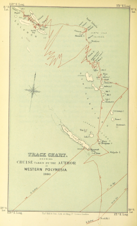
old maps of polynesia
maps from the mechanical curator collection
1760
maps from the earth and its inhabitants, vol. vi
maps of samarkand
maps from the earth and its inhabitants, vol. ix
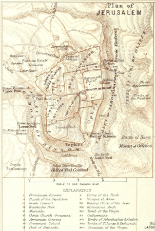
old maps of the holy land
a school geography (1898) by bird
old maps of the yellow sea
old maps of southeast asia
maps by thomas starling
propaganda map
1529 maps
propaganda map
1529 maps
chorographia britanniae (1741-1742)
18th-century maps of cornwall
chorographia britanniae (1741-1742)
18th-century maps of kent
maps by emanuel bowen
1747 maps of africa
cassell's old and new edinburgh (1880s)
holyrood palace
chorographia britanniae (1741-1742)
18th-century maps of essex
untrodden peaks and unfrequented valleys (1873)
maps of south tyrol
maps by thomas kitchin
1781 maps of europe
maps from the earth and its inhabitants, vol. xviii
old maps of valparaíso
maps from the earth and its inhabitants, vol. iv
old maps of the firth of forth
maps from the earth and its inhabitants, vol. iv
old maps of bristol
maps from the earth and its inhabitants, vol. vii
dungan revolt
maps from the earth and its inhabitants, vol. xviii
old maps of valparaíso
maps from the earth and its inhabitants, vol. xvi
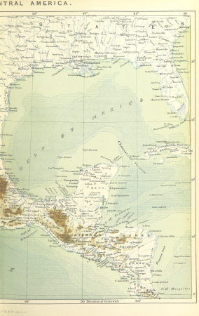
old maps of central america
maps from the earth and its inhabitants, vol. iv
1870s maps of london
maps from the earth and its inhabitants, vol. iv
old maps of the river thames
maps from the earth and its inhabitants, vol. iv
1870s maps of london
old maps of the strait of gibraltar
a school geography (1898) by bird
chorographia britanniae (1741-1742)
18th-century maps of sussex
maps from the earth and its inhabitants, vol. iv
falkirk
maps from the earth and its inhabitants, vol. iv
old maps of edinburgh
maps from the earth and its inhabitants, vol. iv
old maps of edinburgh
maps from the earth and its inhabitants, vol. vii
charles eugène perron
german renaissance
old maps of venice
18th-century maps of edinburgh-shire
maps of scotland by herman moll
arnold's geographical handbook (1899)
maps of river clyde
maps from the earth and its inhabitants, vol. xiv
1870s maps of new zealand
old county maps of hertfordshire
maps by thomas kitchin
maps from the earth and its inhabitants, vol. xi
19th-century maps of chad
arnold's geographical handbook (1899)
old maps of the amazon river
arnold's geographical handbook (1899)
1899 maps of the united states
maps from the earth and its inhabitants, vol. iv
maps of lewis, scotland
old maps of south africa
maps of transvaal
18th-century maps of nottinghamshire
chorographia britanniae (1741-1742)
chorographia britanniae (1741-1742)
18th-century maps of westmorland
18th-century maps of huntingdonshire
chorographia britanniae (1741-1742)
chorographia britanniae (1741-1742)
18th-century maps of northumberland
chorographia britanniae (1741-1742)
18th-century maps of cumberland
chorographia britanniae (1741-1742)
18th-century maps of cambridgeshire
chorographia britanniae (1741-1742)
18th-century maps of middlesex
chorographia britanniae (1741-1742)
18th-century maps of monmouthshire
the antiquities of athens (stuart&revett)
greek revival architecture
1870s maps of the caucasus
g. h. swanston
old maps of the polish-lithuanian commonwealth
1790s maps of poland
too late for gordon and khartoum (1887) by macdonald
old maps of the nile
maps from the earth and its inhabitants, vol. xiii
maps of telegraph lines
maps from the earth and its inhabitants, vol. iv
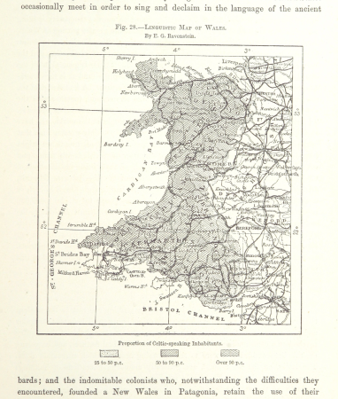
linguistic maps of wales
maps from the earth and its inhabitants, vol. xiv
19th-century maps of borneo
the comprehensive history of england (1876)
english-language maps showing history
1840s maps showing history
maps by thomas starling
a treatise on ore deposits (1896)
1890s maps of saxony
laying the atlantic telegraph cable from ship to shore (1857)
valentia island
chorographia britanniae (1741-1742)
18th-century maps of staffordshire
chorographia britanniae (1741-1742)
18th-century maps of hampshire
chorographia britanniae (1741-1742)
18th-century maps of hertfordshire
101 - 200 of 494
Next page
/ 5


![[The Coast of Mallabar by John Corner, 1741], John Corner](https://cdn.creazilla.com/illustrations/10000515559/the-coast-of-mallabar-by-john-corner-1741-john-corner-md.jpg)